

Cycling Land's End to John o'Groats: Great Britain end to end
Whether you're just dreaming about this classic ride or your bags are already packed, here's everything I learnt from cycling end to end, to help you plan yours.
My LEJOG bike at Cocklawburn beach, Northumberland
Why this site exists
Great Britain, end to end
Land's End to John o'Groats (LEJOG) is the most iconic long-distance cycle ride in the UK. It starts at Land's End, the far south-western tip of mainland Britain, and finishes about 1,000 miles later at John o'Groats, close to the most northerly point. Thousands of cyclists take on the challenge every year, and some have ridden it several times!
I cycled Land's End to John o'Groats in June and July 2016. It was my first cycle tour, and I had hundreds of questions: What should I pack? Where would I stay? How do I plan a safe LEJOG route? I wasn't even sure how I'd get to Land's End, or home again from John o'Groats - let alone with my bike!
I learnt a lot on that trip, so I built this website to help anyone thinking of doing this iconic ride. (Do it - you won't regret it!) Since then I've completed three more cycle tours of over 1,000 miles each, including a 2,570-mile tour around the coast of northern UK (CyclingTheUK.com), and the lessons from those trips are here too.


Plan your ride
Planning a LEJOG or JOGLE ride?
Whether you're riding fast or slow, solo or in a group, unsupported or with a back-up driver, start with whichever guide you need.

Route planning & navigation
How to approach planning a route, and how to navigate as you ride.

LEJOG route download
GPX route files for the whole ride, reviewed and updated in 2024. They work for JOGLE too - just reverse them.

Kit list
Everything I took with me, to give you ideas for what to pack.

Training & fitness
How to train for LEJOG, plus tips for avoiding the most common injuries.

Getting to the start & home
Ways of getting you and your bike to Land's End and John o'Groats, and back again.

Safety & security
Staying safe on the road, the tricky sections, and keeping your bike secure.

My LEJOG diary
The day-by-day diary I kept throughout my trip, with lots of photos.

Common questions
Answers to the questions people ask most, from cost to fitness.

Route planning tools
Step-by-step guides to Strava, Google Maps and loading routes onto a Garmin.

T-shirts & souvenirs
T-shirts and mugs to celebrate your ride, for LEJOG and JOGLE riders.

Useful books
Cycle touring books to help you prepare, and to inspire you. (Affiliate link to Bookshop.org.)

Useful links
Train companies' cycle policies, accommodation and other LEJOG resources.

Ready-made route
Skip the hours of route planning
Planning a LEJOG route takes far longer than most people expect. Start from the 1,020-mile route I rode, designed to follow quiet roads and traffic-free paths, avoid the most dangerous roads like the A30 in Cornwall, and keep the climbing down. It was fully reviewed and updated in 2024.
- 29 GPX route files, ready for Garmin, Wahoo, Hammerhead and more
- 3 alternative routes through northern Scotland
- A 30-page PDF guide with route notes and places to see
- Works for JOGLE too - just reverse the files
The basics
How far is it from Land's End to John o'Groats?
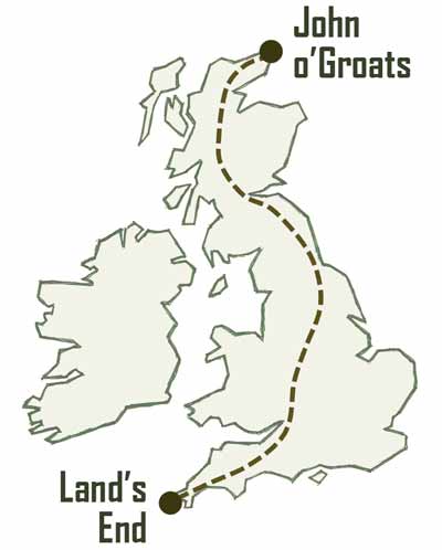
The shortest route by bike (avoiding motorways) is around 900 miles, and avoiding major roads brings this up to over 950 miles. Once you add detours to your accommodation each night or around the worst hills, most people end up riding around 1,000 miles.
There's no "official" route and people take all sorts of ways north. When I rode it I went via Leeds (my home city), cycling 1,060 miles in total, although most people stay west of the Pennines and thread up between Liverpool and Manchester.
From speed attempts in as few as five days to leisurely trips that are all about exploring the UK, anyone who can ride a bike can manage this world-famous ride. You don't have to be superfit either - I certainly wasn't!
Many people ride it for charity, while for others it's a bucket-list challenge. Some choose to ride north to south instead, often called JOGLE (John o'Groats to Land's End).
All sorts of bikes have been used, from recumbents and tandems to fixed gears and mountain bikes - even unicycles and penny-farthings! Hundreds of people walk or run the route each year, and it has even been swum, most recently in October 2022.


Quick answers
LEJOG and JOGLE: quick answers
What's the difference between LEJOG and JOGLE?
LEJOG is Land's End to John o'Groats, riding north from the tip of Cornwall to the far north-east of mainland Scotland. JOGLE is the same ride in reverse: John o'Groats to Land's End, heading south. The distance and the achievement are the same either way.
Is it better to cycle LEJOG or JOGLE?
Neither is better, although LEJOG seems to be the more popular. The prevailing wind supposedly blows south to north more often, and heading north in summer keeps the sun behind you. On a JOGLE you reach Cornwall at the end of your trip, so check accommodation if that falls in the school holidays. More on choosing which direction to ride.
How far is JOGLE?
The same as LEJOG. The shortest route by bike is around 900 miles, but most people ride about 1,000 miles once they've avoided the busiest roads and added detours to their accommodation each night.
How long does it take to cycle LEJOG or JOGLE?
Most people take between 10 and 21 days, and two weeks is a popular target to fit around holiday allowance. Some riders do it in five days; I took 29. See the LEJOG & JOGLE FAQs for daily mileages and fitness.
Where can I stay during a LEJOG trip?
There are plenty of B&Bs and hotels along the whole route, plus youth hostels, which are cheaper but fewer and further between. Camping means carrying more kit, but lets you stop wherever you've had enough for the day (with the landowner's permission). I preferred a comfortable B&B each night. Cornwall gets busy in the summer holidays, so book those nights early. More on finding LEJOG accommodation.
How do I get to Land's End to start a LEJOG?
The nearest station is Penzance, 10 miles from Land's End, with Great Western Railway trains via Plymouth. Bikes travel free, but you'll need to reserve a cycle space when you buy your ticket, and they can be snapped up weeks in advance. More on getting to the start and home again.
How do I get to John o'Groats to start a JOGLE?
The nearest station is Wick, 16 miles away, with 3 to 4 trains a day from Inverness. In summer the John o'Groats Bike Transport Company runs a shuttle bus for riders and bikes from Inverness, and can courier your bike up to meet you. More on getting to the start and home again.
Can I use a LEJOG GPX route for JOGLE?
Yes. My LEJOG GPX route files work for JOGLE too: ride the days in reverse order and reverse each file in your GPS or route-planning app.
How much does it cost to cycle Land's End to John o'Groats?
Anything from a few hundred to several thousand pounds. The biggest factors are how long you take, where you stay and how much kit you already have. My B&Bs averaged about £70 a night (in 2016) - camping will be substantially cheaper.
Celebrate your ride
LEJOG & JOGLE t-shirts and mugs
Cycling the length of Great Britain is quite an achievement. Mark it with a t-shirt or mug - several designs and colours, with versions for both LEJOG and JOGLE riders. Delivery is free within the UK.


Cycle touring bingo
Just for fun: tick off the boxes as you ride across Britain. Touring with friends? See who gets a full house first.
Download the card (PDF)Found this website useful?
I'd be incredibly grateful if you'd support the hosting and upkeep of the site with the price of a coffee. Thank you!

Got tips from your own ride?
If you've ridden LEJOG or JOGLE, or have any feedback on the site, I'd love to hear from you.
Email andy@cyclelejog.com